WSi News2018-10-29 11:48:56
Fight against the UAV threat with 360° Thermal sensors SPYNEL by HGH Infrared Systems
Terrorism by unmanned aircraft is a growing threat. While many countries are using drones in combat, the UAV technology is getting easier and easier to acquire by the general public and ill-intentioned groups. Most of current security systems are not sufficient to guarantee an appropriate level of protection.
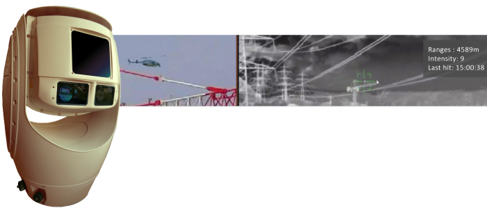
To confront this situation, HGH Infrared Systems developed its most powerful 360° Thermal imaging sensors SPYNEL-X and SPYNEL-S, integrating a Visible Channel and a Laser Range Finder to the thermal cameras. The new V-LRF option aims to facilitate the tracking and the identification of a detected threat, thanks to the Full HD visible cameras’ optical zoom (x30). The exact distance of the threat is provided by the laser-range finder in real time, an option particularly adapted to the detection, tracking and recognition of small targets, even the smallest drones.
An innovation it is, as all other systems on the market must use separate sensors to get similar functions: one sensor for detection, a radar for instance, and another sensor for identification, such as a PanTiltZoom camera. Cyril Marchebout, Sales Manager at HGH Infrared Systems explains: «With separate systems, it is hardly possible to ensure a real 360° coverage for detection and identification because of blind sectors created by the mechanical supports. Moreover, separate sensors must be integrated and calibrated to properly operate together. SPYNEL & its V-LRF option ensure no blind zone for a real 360° coverage in all surveillance phases: detection & identification.» In addition, most of the time, UAVs' small size and low electromagnetic signature go unregistered by traditional detection measures. With Spynel's thermal imaging technology, it is impossible for a drone to go unnoticed: any object, hot or cold will be detected by the 360° thermal sensor, day and night
SPYNEL V-LRF and its automatic detection & tracking software CYCLOPE are easy to deploy and to use, and the system is easily interfaceable for multi-sensor protection of critical infrastructure. Data is easily merged with other sensors’ data like radars, AIS, fence vibration sensors, etc., and displayed on the same interface, whereas separate sensors must be integrated and calibrated to operate properly together.
For more information contact: