ILOG


Command and Control

Terrain Anaysis

World Map Custom Projection with MGRS grid

Map of Los Angeles

Street Level Map

ILOG Company Profile for DSEi CD Issue

ILOG delivers software and services that empower customers to make better decisions faster and manage change and complexity. Over 2,500 global corporations and more than 465 leading software vendors rely on ILOG's market-leading business rule management system (BRMS), optimization and visualization software components, to achieve dramatic returns on investment, create market-defining products and services, and sharpen their competitive edge.

  • ILOG BRMS. Applications gain flexibility with ILOG's Business Rule Management System. ILOG business rule engines deploy and apply policy changes across the enterprise. You rapidly react to customer demands, regulatory changes and competition.
  • ILOG Optimization. Develop the best plans and schedules to maximize service, revenue and profits. ILOG optimization technology copes with any number of operating constraints. You gain the confidence to make the right decision at the right time, reducing risk.
  • ILOG Visualization. Complex data comes to life with ILOG visualization technology. ILOG visualization sharpens the big picture, translating data into usable information.

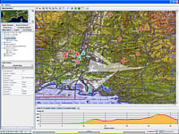
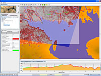
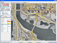
ILOG JViews Maps for Defense - Military visualization you need

From the leading supplier of software components, ILOG JViews Maps for Defense provides high-level components and powerful off-the-shelf features that enable developers to go from prototype to deployable tactical applications in the shortest time possible. The flexible cross-platform approach guarantees that you can create well suited, vendor-independent custom solutions, while pre-built and pre-tested components save in-house development costs. Domain-specific features include all of the major military map formats and symbol sets, high-precision grids and coordinate systems, terrain analysis services, and many customizable graphical representations.

  • Advanced map data layering for building a common operational picture (COP) using multilayered maps and graphic objects to show context-based information.
  • Extensible library of symbology that can be automatically updated in real time to accurately show position and status data for targets and deployed assets.
  • Geointelligence and terrain analysis capabilities for assessing field conditions and making better deployment decisions.

Tactical advantage for achieving victory

The success of any military operation depends on careful planning that can only be accomplished with accurate maps. ILOG JViews Maps for Defense provides a full range of high-level, cross-platform components and powerful off-the-shelve features for building detailed map displays. It also enables developers to go from prototype to deployment in the fastest time possible. From military planners to troops in the field, users get displays with video-like performance for fast navigation and immediate situation analysis. ILOG JViews Maps for Defense delivers a tactical advantage for achieving victory.


> Index
     > Security Equipment & Systems
          > Information Technology
               > Software Development
               > Geographic Information Systems (GIS)
               > Computer Software
                    > Information Systems Management
                    > Intelligence and Analysis


Records not found!

Records not found!

Records not found!

Records not found!

October 2006

ILOG 9th October 2006

ILOG Unveils Industry's First System for Developing Custom Optimization-Based planning and scheduling Applications Solution Brings Together [more]


Records not found!

Records not found!


Records not found!


Records not found!

ILOG

3-5 Avenue Gallieni
Gentilly
94257
France


Email: info@worldsecurity-index.com By using worldsecurity-index.com you are agreeing to our Conditions of Use.
© KNM Media Kent Ltd 2024. All rights reserved.